Scott Byram, Ph.D., R.P.A.
Project Efficiency with a Focus on Features and Stratigraphy
As a consultant and a researcher, Scott Byram uses GPR to identify and characterize buried archaeological features and strata at known sites, to locate new sites and site components, and to clarify the locations of known significant sites that are otherwise inaccessible without ground disturbance.
Ground-penetrating radar is often the most effective non-destructive subsurface scanning technique used in archaeology, and over the past 15 years Byram has employed this technique at a wide variety of sites, enhanced by his breadth of experience with site formation studies in diverse settings. Worldwide, GPR is increasingly applied in archaeology to delineate strata and features. Byram has conducted numerous GPR projects in California, Oregon, Hawaii, Europe and South America. Even in the most limiting site settings there may be information to be gleaned from GPR survey. Few open settings are unsuited to GPR survey provided focal deposits are relatively intact, not at great depth, and not saline or covered with debris, especially metal. Archaeological GPR depth range is often comparable to typical excavation unit depth, and sometimes much greater.
Most of Byram’s projects require two or more days of fieldwork, in addition to analysis and report preparation. Byram often works in conjunction with archaeologists and agency land managers on historic preservation planning projects, using state of the art equipment manufactured in the U.S. by Geophysical Survey Systems, Inc., including the SIR4000 controller and a 350HS digital hyperstacking antenna, as well as the IDS Stream-C multichannel system with 32 antennae at 600 MHz frequency.
Examples of sites where Byram has conducted GPR studies:
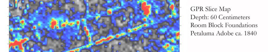
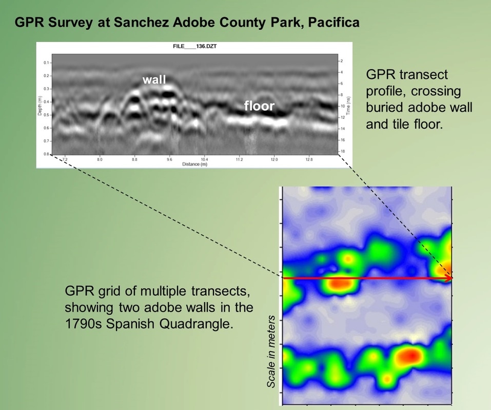
Historic Adobes, Missions & Presidios: Mission San Juan Bautista; Mission Santa Clara; Sonoma Mission; Sanchez Adobe (Pacifica); Castro Adobe (Watsonville), Machado y Smith in Old Town San Diego; Vallejo's Petaluma Adobe; Mission San Jose.
Stone structures: Palehua Site Oahu, Hawaii; Peyre Blanque Magdalenian Site, Ariege France; Old Town San Diego.
Shell Mounds and Villages: Stege Mounds in Richmond; West Berkeley Mound; Butano Mound in Pescadero; Pruristac Village in Pacifica; Tseriadun site 35CU7; Coquille River site 35CS1; Tom Vaquero village Tomales Bay; Jack Kirk site Mariposa Creek; Wassama State Park; China Camp SP; Portola Valley sites; Bodega Bay SP; Quirosote at Año Nuevo; Neolithic long barrows in Muszkowice, Poland.
Cemeteries: Several Tribal cemeteries in Oregon and California; Presidio San Francisco; Redding Memorial; Rose Hill Cemetery, Black Diamond Mines, Ojai-St. Thomas Aquinas, Mission San Gabriel Los Angeles, Kernville Cemetery, Mooretown Cemetery.
Military Sites: Monterey Presidio; Camp Castaway shipwreck post; Fort Ross Russian stockade, Presidio Barracks in San Francisco; WWII bomber crash in SW Poland.
Homestead Sites: in Yuba, Alameda, Mendocino and Sonoma counties, CA and Coos County, Oregon.
Historic Buildings: Jack London Square; Petaluma Chinatown; California State Capitol and Capitol Park; Peralta Adobe in Oakland; Silverton Oregon CCC camp; railroad buildings in Sonoma County and Ventura County; and Campus buildings at UC Berkeley, Santa Clara, and San Diego State universities.
Tunnels and Mining Features: Forestiere Underground Gardens; Black Diamond Mines; Tule Lake Japanese Interment Camp
Geology/Paleontology: Port Orford marine terraces; San Andreas fault at San Juan Bautista; Oregon Dunes; Pliocene paleontology in Christmas Valley, Oregon; Basalt lava flows in Hawaii; limestone terraces in Ariege, France.
Project Efficiency with a Focus on Features and Stratigraphy
As a consultant and a researcher, Scott Byram uses GPR to identify and characterize buried archaeological features and strata at known sites, to locate new sites and site components, and to clarify the locations of known significant sites that are otherwise inaccessible without ground disturbance.
Ground-penetrating radar is often the most effective non-destructive subsurface scanning technique used in archaeology, and over the past 15 years Byram has employed this technique at a wide variety of sites, enhanced by his breadth of experience with site formation studies in diverse settings. Worldwide, GPR is increasingly applied in archaeology to delineate strata and features. Byram has conducted numerous GPR projects in California, Oregon, Hawaii, Europe and South America. Even in the most limiting site settings there may be information to be gleaned from GPR survey. Few open settings are unsuited to GPR survey provided focal deposits are relatively intact, not at great depth, and not saline or covered with debris, especially metal. Archaeological GPR depth range is often comparable to typical excavation unit depth, and sometimes much greater.
Most of Byram’s projects require two or more days of fieldwork, in addition to analysis and report preparation. Byram often works in conjunction with archaeologists and agency land managers on historic preservation planning projects, using state of the art equipment manufactured in the U.S. by Geophysical Survey Systems, Inc., including the SIR4000 controller and a 350HS digital hyperstacking antenna, as well as the IDS Stream-C multichannel system with 32 antennae at 600 MHz frequency.
Examples of sites where Byram has conducted GPR studies:
Historic Adobes, Missions & Presidios: Mission San Juan Bautista; Mission Santa Clara; Sonoma Mission; Sanchez Adobe (Pacifica); Castro Adobe (Watsonville), Machado y Smith in Old Town San Diego; Vallejo's Petaluma Adobe; Mission San Jose.
Stone structures: Palehua Site Oahu, Hawaii; Peyre Blanque Magdalenian Site, Ariege France; Old Town San Diego.
Shell Mounds and Villages: Stege Mounds in Richmond; West Berkeley Mound; Butano Mound in Pescadero; Pruristac Village in Pacifica; Tseriadun site 35CU7; Coquille River site 35CS1; Tom Vaquero village Tomales Bay; Jack Kirk site Mariposa Creek; Wassama State Park; China Camp SP; Portola Valley sites; Bodega Bay SP; Quirosote at Año Nuevo; Neolithic long barrows in Muszkowice, Poland.
Cemeteries: Several Tribal cemeteries in Oregon and California; Presidio San Francisco; Redding Memorial; Rose Hill Cemetery, Black Diamond Mines, Ojai-St. Thomas Aquinas, Mission San Gabriel Los Angeles, Kernville Cemetery, Mooretown Cemetery.
Military Sites: Monterey Presidio; Camp Castaway shipwreck post; Fort Ross Russian stockade, Presidio Barracks in San Francisco; WWII bomber crash in SW Poland.
Homestead Sites: in Yuba, Alameda, Mendocino and Sonoma counties, CA and Coos County, Oregon.
Historic Buildings: Jack London Square; Petaluma Chinatown; California State Capitol and Capitol Park; Peralta Adobe in Oakland; Silverton Oregon CCC camp; railroad buildings in Sonoma County and Ventura County; and Campus buildings at UC Berkeley, Santa Clara, and San Diego State universities.
Tunnels and Mining Features: Forestiere Underground Gardens; Black Diamond Mines; Tule Lake Japanese Interment Camp
Geology/Paleontology: Port Orford marine terraces; San Andreas fault at San Juan Bautista; Oregon Dunes; Pliocene paleontology in Christmas Valley, Oregon; Basalt lava flows in Hawaii; limestone terraces in Ariege, France.
Contact: scottbyram@featuresurvey.com
Links:
https://berkeley.academia.edu/ScottByram
https://works.bepress.com/byram/works.bepress.com/byram/
Book: Triangulating Archaeological Landscapes (2013)